Green Belt Site Induction
Green Belt Site Induction
Contractor Questionnaire
Contractors are required to complete this attached document. Once completed, please return to reception@greenbelt.ie
Timber Supply Contracts
Timber Supply Contracts provide sureties over the supply of material for infrastructure projects.
For example, data centres now require an additional energy source that is deemed renewable. Biomass is a perfect solution for this approach and can support the sustainability criteria for these operations.
Other projects that have successfully implemented biomass usage include
- Hotels
- Chicken farms
- Office blocks
- Housing developments
- Industrial units
- And more….
Green Belt is uniquely placed to provide a guaranteed volume of material annually to your project. It can be delivered in round log or wood chip form and at a variety of moisture content levels.
Get in touch to explore how you can make forestry work for you.
Taxation in Relation to Forestry and Woodlands
Taxation in Relation to Forestry and Woodlands
Income Tax and Corporation Tax
Profits or gains from the occupation of woodland in the State which is managed on a commercial basis and with a view to a profit are exempt from Income Tax and Corporation Tax (but not Universal Social Charge and Pay Related Social Insurance)
Capital Gains Tax
In the case of individuals, the value of the standing timber is not taken into account for CGT purposes. Where an individual disposes of woodlands, capital gains tax is chargeable on the lands only and not on the trees growing on the lands.
What is the position with inheritance tax on my forestry?
Your children for example, can inherit the forestry, subject to valuation and the threshold limits. They must retain it for 2 years before selling it on, but can manage it in the meantime – this can mean they can harvest timber from the forestry.
Invest in Forestry
Invest in Forestry
Green Belt works with private investors, wealth funds and institutions interested in building a portfolio of forestry assets. Forestry is an excellent hedge versus inflation, and is a secure investment as harvesting can be based on positive market conditions.
Frequently Asked Questions on Investment in Forestry
What is the typical term for forestry investment?
It can range from 10 years onwards. The options for investment can include semi mature forestry, purchasing 'green land' for planting (attracts grants and premiums, and land is expensive, or buying 'Brown land' for replanting (no grants or premiums but land is less costly)
How Does Green Belt work with me?
Green Belt carries out extensive due diligence on lands or forests that meet your investment criteria. This includes desk top surveys, drone mapping and on site inventory. The data is compiled into a detailed spreadsheet outlining the total income and expenditure across the lifecycle.
What is the typical IRR from a forestry investment?
We realistically predict a 3-4% IRR, compounding, for forestry investments. This is a tax free return, except for USC and PRSI, based on the current rules applying.
What tax is paid on forestry investment?
The income derived from the occupation of commercial woodland is tax free, except for PRSI and USC. If you hold shares in a forestry investment, the transfer of shares is taxed, but the income derived from the occupation of commercial woodland is tax free. The forestry crop is not liable to CGT or to Stamp duty. Read more on the Taxation including Inheritance Tax in Relation to Forestry and Woodlands
Do I earn anything during the investment term, before clearfell?
You could earn from the tax free annual premiums paid for 15 years on new plantations. Earnings from forestry thinning operations can be paid out as dividends. We can compile a structured forestry portfolio to provide regular dividends to investors.
What value has my forestry in Biodiversity credits?
Nature based solutions are increasingly important for companies with reporting obligations and compliance requirements. Baselining the biodiversity function of the forests or woodland provide data to present in terms of CSRD reporting for example.
What risks is my forestry investment open to?
There are risks from fire, wind and pestilence. These can be mitigated against but can still persist. Forest insurance is recommended and available through Green Belt Ltd. Economically, there are market risks but as timber is best stored on the stump, it can increase in value as the markets recover. With a strategic view of your forestry portfolio, Greenbelt can manage economic risk effectively.
Why is forestry the best investment?
- Low risk to return ratio;
- Biological growth is not impacted by economic factors, it is safe and reliable;
- Generally a negative correlation to stock market indices;
- Traditional risks can be avoided through professional forest management;
- A forest is a tangible asset which is a source of value creation;
- Irish timber has an incredible untapped value for the bioeconomy;
- It is becoming more valuable as Carbon Capture becomes more important.
Download Documents:
![]() Download the Afforestation Grant and Premium Scheme 2023 - 2027 (pdf)
Download the Afforestation Grant and Premium Scheme 2023 - 2027 (pdf)
Forestry & Land Valuations
Green Belt has been active in land and forestry acquisition since 1982. Over more than 40 years, and planting more than 600 million tree's, we have facilitated the purchase of thousands of acres of land across Ireland, and even much further afield.
Gathering the data to appraise an existing forestry holding, or a potential purchase of land or forestry, is part of the professional service we offer clients.
We consider all aspects of the plantation, including access, viability of new planting (land purchase), health of the crop (existing forests), future earnings and additional benefits, such as ecosystem services.
All this information is presented in a practical and easily understood format.
There are many uses of this information and some of those are listed below.
- Selling or buying forestry or land
- Insurance (Green Belt offers comprehensive forestry insurance)
- Compensation
- Wind Damage
- Financial investment
- Institutional investment
- Probate
- Valuations
If you have a specific query or issue to be addressed, please get in touch.
Land Acquisitions
Any forestry and woodland project requires suitable land. Green Belt can source and acquire those lands for you, across the country.
For more than 40 years, Green Belts foresters have worked with local land owners and agents to acquire lands that meet the criteria for planting.
We continue to leverage those relationships to provide a full service solution to our clients who are often too busy to be able to find the land themselves.
Once identified using our screening service and expert on field assessment, the appropriate application can be submitted to the forest service.
Wood Chipping
Green Belt harvests significant volumes of material nationally. Each year, we carry out thinning and clearfell operations for private landowners and, as part of our role, we market the timber to appropriate markets.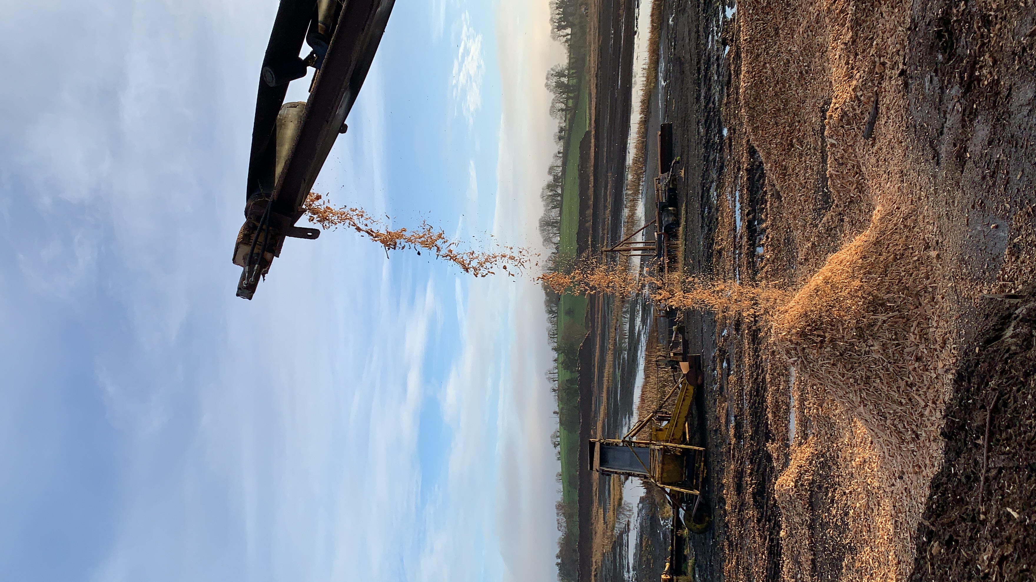
One such market is the biomass/ Pulp market. In Ireland, the main offtakers for this material are Bord Na Mona (BNM) and other groups using woody biomass for heating and CHP facilities. These include hotels, chicken farms, supermarkets and so on.
Green Belt can facilitate the chipping and delivery of material to specific locations, and we can enter into supply contracts based on volume, distance and price.
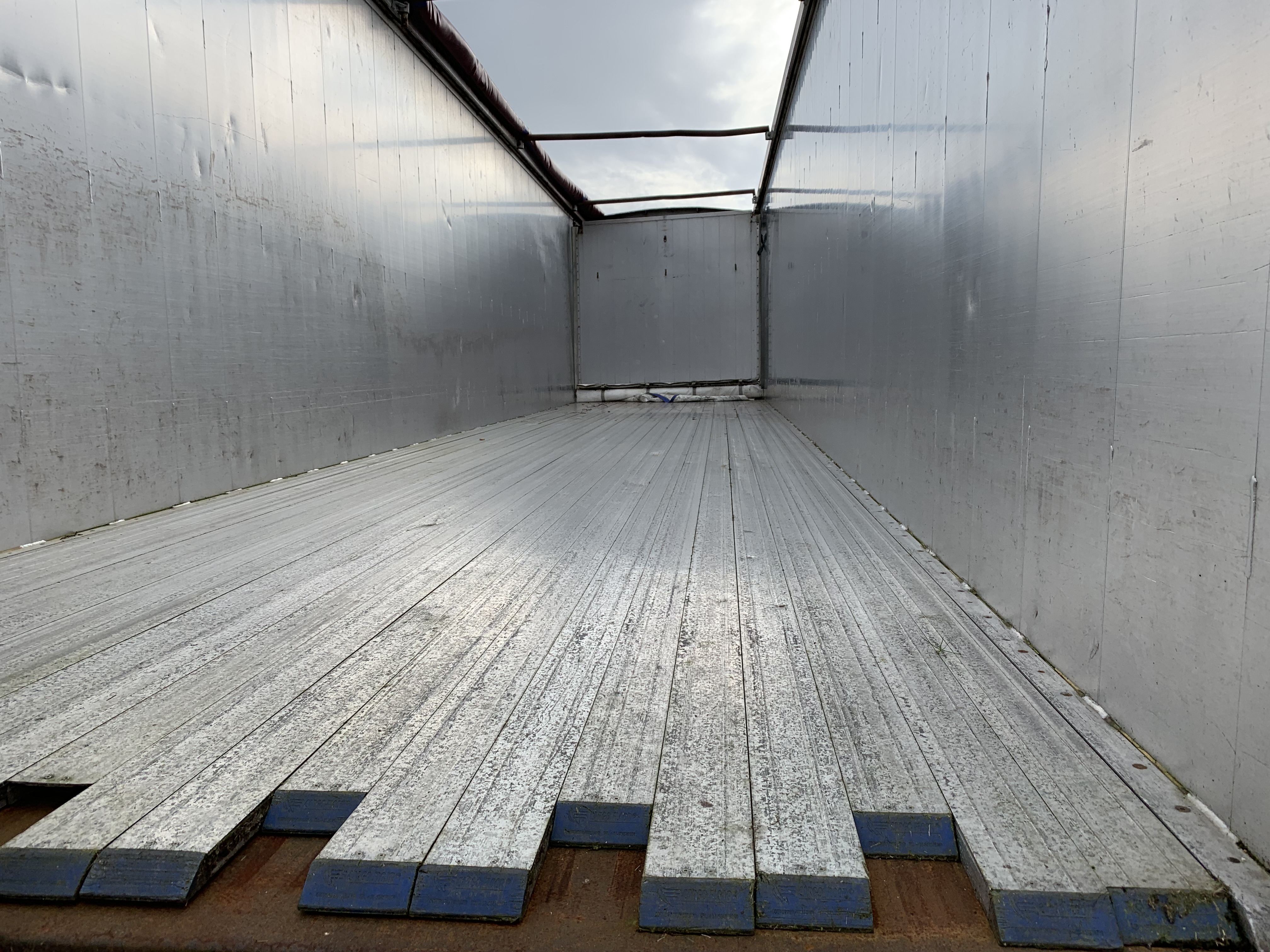
The material is delivered in walking floor trailers and deposited where specified - typically a location that is dry and has facilities to draw it to the heating unit.
If you have a project you are looking for a secure supply of material for, including Biochar production, please get in touch.
Timber Marketing & Sales
Green Belt leverage our excellent reputation and national presence to achieve the best price for your timber from any harvesting event.
First thinning's - can be essential to improve the long term volume and value within your crop. 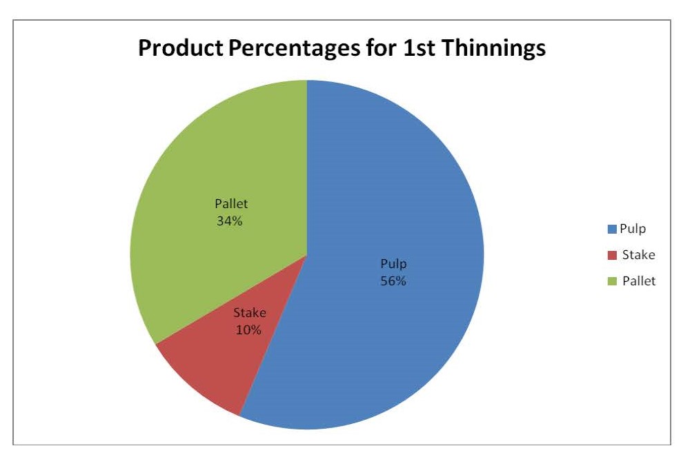
Majority of timber removed will be smaller material called pulp and will be between 55 and 60% of the gross volume. Important to note that thinning is for future value creation.
Subsequent thinning's - carried out when appropriate. The volume of Pulp will reduce as these occur.
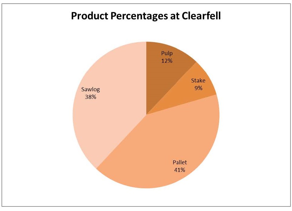
Clearfell - This should be the time you earn most from your forest. Green Belt will market your timber and acquire the best price and the best conditions - time, operations, impact and so on.
Forest Roads
Sustainable and long term access to your forest is a very important element to the protection, maintenance and harvesting of your wood. The DAFM provides financial support in the form of a Road Grant that allows 25 linear metres per hectare to be constructed*.
A Forest road application must be submitted by a professional forester and our nationwide forestry professionals will guide you though the entire process. We will supervise the road construction and ensure it meets Forest Service standards as set out in the guidelines.
The construction of forest roads can be a challenging prospect, for example, due to difficult terrain, inaccessibility to stone and steep slopes. Our expert road construction teams have met these challenges and delivered an excellent infrastructure for countless forest owners all over Ireland.
The details of the scheme are HERE
This does not preclude you from extending the road however.